Report: Ohio Rail Commission Releases Public Rail Crossing Impact Tool
Written by Carolina Worrell, Senior Editor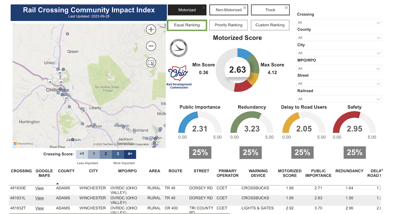
The Ohio Rail Development Commission (Rail Commission) has released a free, publicly accessible tool to “measure the impact of blocked rail/roadway at-grade crossings in Ohio, according to a Circleville Herald report.
According to the report, the Rail Crossing Community Impact Index (RCCII) is “an interactive tool that allows users to find crossings within their own community and creates weighted scores for motorized, non-motorized, and truck-specific traffic.”
According to the Ohio Rail Commission, RCCII, which was developed over 18 months, scores the crossings based on their impact to communities and emergency services, proximity to the nearest alternative route, expected delay and safety.
The scores, the Rail Commissions says, “can provide a way to identify areas with the most significant impact and help prioritize locations during the project selection process.” In addition, the tool provides important information to support rail improvement program development such as discretionary grant funding applications.
Scores range from zero (least important) to five (most important). Each of the three scores, the Rail Commission says, are calculated using data specific to the types of road users. For example, a two-mile detour is inconvenient for a vehicle user but poses a greater challenge for a pedestrian or bicyclist.
According to the Circleville Herald report, the Rail Commission’s website gave several scores to Pickaway County Crossings, including 15 locations in Circleville. The three highest scores were West Main Street at 3.55, South Court at 3.16 and West High Street at 3.12. The West Main Street crossing was buoyed by a 4.4 score for safety. Information provided by the tool shows that more than 10,400 vehicles pass over the crossing each day. South Court Street sees about 7,600 vehicles per day.
In Ashville state Route 752’s crossing was the highest at three withe the second highest being state Route 316 at 2.97.
“The Rail Crossing Community Impact Index will be a significant asset for the Rail Commission, its partners, and the public,” said Ohio Rail Development Commission Executive Director Matthew Dietrich, in a press release. “By providing a publicly available tool to measure the relative impact of blocked at-grade crossings, all users will benefit from the information provided for a specific crossing or group of crossings, and how they measure up in relation to the statewide average.”
The tool is currently available here. The results are searchable by county and community.